Printed from: https://finalhbks.asgoodasready.com/sand-dunes/a-look-at-sand-dunes/accretion-and-erosion/
General factors
Sea levels
Today’s coastlines have been shaped in large part by changing sea levels since the end of the Ice Ages, about ten or twelve thousand years ago. Minor fluctuations are still occurring. Where land is rising relative to sea level, more material is made available for dune formation. Where land is sinking, it appears that intertidal steepening is occurring, with high and low water line approaching one another. In the 30 years up to 1911, a net loss of 19,000 hectares (47,000 acres) of intertidal land in Britain was recorded. Detailed studies have not been done, but this loss could be either from the high water line moving outwards due to reclamation or progradation, or the low water line moving landwards. It appears that the latter is occurring, as progradation has taken place on less than 7% of the English coastline since the late 19th century (May, in NCC, 1985). This steepening allows greater wave energy to act on the shore, with potential beach erosion.
The general pattern in Britain appears to be that the land is tilting on an axis, with the South East sinking relative to sea level, and the north and west rising.
Trends in sea levels are difficult to record, but past developments can sometimes be deduced from topographical features and stratigraphy. For example, dunes which are homogenous in cross-section suggest relatively rapid development in the past, while shingle horizons preserved in dunes (as opposed to existing basement shingles underlying homogenous dunes) indicate cycles of development and erosion during the dunes’ history.
Sources of sediment
Supplies of sediment for the formation of sand and shingle banks and sand dunes may come from eroding land surfaces, the coastline itself or the sea bed mainly during high winds and rains. ‘Young’ rivers, or those flowing through existing dunes and beaches, bring down suspended sand and provide material for beach and dunegrowth. Most rivers in Britain are relatively ‘mature’ and transport finer materials which go towards the construction of mud banks. Eroding cliffs also supply beach and dune sediments, not always for deposition nearby. Where neither river nor cliff erosion seems responsible for a particular coastal feature, Ritchie (1972, p29) argues the strong probability of glacial origin, ie reworked clays, sands and gravels laid down by glaciers when sea levels were lower. Submarine glacial deposits seem to be the prime source of material, for example, for the banks and bars of the north Norfolk Coast.
The amount of sediment available is affected by changes elsewhere on the coastline. Urban and industrial development on the coast, and the construction of coastal defences to stop erosion may mean a loss of sediment supply to other parts of the coastline. The extraction of sand and gravel for building, industrial and agricultural use can also decrease the supply to nearby beaches and dunes.
Current and wave action
Below the range of the highest storm tides, currents and breaking waves are the main determinants of coastal sediment features. The effect of currents depends not only on their strength but also on the behaviour of mud and sand particles in a mass and on the formation of eddies which can locally increase current speed. The effects of breaking waves are rather more easily generalised. The diagram below shows how waves which approach a shoreline obliquely push material along the beach with the swash and pull it down with the backwash.
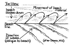
The overall direction of drift depends on the orientation of the beach relative to the prevailing winds. For example, drift is eastward along the Sussex Coast, due to the prevailing westerlies, but southward along the Suffolk coast, which receives the full force of northeasterly storms.
The interaction of storms and swells, ‘destructive’ and ‘constructive’ waves, is complex. Storm waves are ‘destructive’ in the sense that they break steeply and have a relatively powerful backwash, but they may in fact cause most beach accumulation by moving large stones and shingle far up the beach.
Wave action only rarely reaches the sand dunes backing the beach, but when it does it can be disastrous, biting away yards of foredune at a time. Any measures aimed at protecting dunes from the sea must be based on exceptional rather than typical wave conditions.
Wind action
Wind is the main agent of sand dune formation. A wind speed as low as 5 metres per second (about 16km/hr, 10mph) can lift sand grains from a bare surface and start them moving. However, the grains are not merely carried in the wind and deposited as wind speeds slow, but move along by a process called ‘saltation’, described below.
The rough surface of the sand grains on a beach slows the wind by surface drag, and creates a zone of still air immediately above the surface. This zone is 1/30 of the average grain diameter of the sand, for example 0.03mm for 1mm diameter sand grains. When a wind of 5 metres a second or more blows across the surface, those grains which protrude above the zone of still air will roll or slide forward until they meet larger immobile grains. The impact flicks the smaller grain up into the air. The grain moves forward in the pattern shown below, ploughing back down into the sand surface, and exploding more grains into the air. This domino effect causes the beach downwind of the original grain to be alive with moving sand grains in a ‘saltating cloud’.
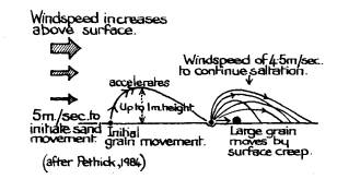
Larger sand grains, up to six times the diameter of the saltating grain, are jerked forward by the descending grains in a process called ‘surface creep’. This causes sorting of the grains, the saltating grains moving further downwind than those moved by surface creep. Very fine grains remain in the zone of still air, and are only lifted by the action of vehicles or feet on the sand surface. These fine grains, once disturbed, may become suspended or blown away from the dunes, or they may collect on the top of the higher dunes.
The amount of sand transported depends on the cube of the wind velocity. For example, on a stormy day with a wind velocity of 50km/hour, 0.5 tonne of sand may be moved per metre width of beach per hour (Pethick, 1984). An increase in wind speed by 16% to 58km/hour, will increase the amount of sand transported by 100%, to 1.0 tonne per metre width per hour. Sand movement is therefore very responsive to wind speed. The occasional very high wind will influence dune alignment and position more than steady prevailing winds, if these are different.
During saltation, there is a balance between energy losses and gains, according to the type of surface. Softer surfaces absorb more energy and result in less transport. A saltating cloud passing over a soft sandy surface will lose energy, causing a decrease in transport rate and increased deposition. An area of shingle or concrete will cause an increase in transport rate and the hard surface will be swept clean.
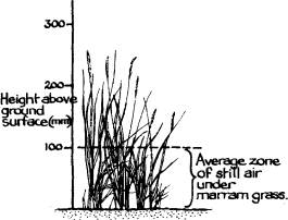
The effect of the foredune vegetation on the saltating cloud is dramatic. Firstly, the vegetation intercepts the descending saltating grains, and being a soft and springy surface, absorbs much of their energy. Secondly, a zone of still air is created very much greater than that on a sandy surface. This zone can be as high as 180mm (8″), depending on the species and density of vegetation. As the saltating cloud reaches the vegetation saltation is greatly reduced, as few grains are propelled up out of the zone of still air. Saltation cannot be initiated within the vegetation, because of the zero wind velocity at the surface.
These two effects cause rapid deposition, which can range from 0.3m to 1m (1-3′) per year. As described on page 70, the physiology of the dune grasses has to be able to cope with this inundation.
The overall height of a dune is determined partly by average wind speed in the area, and partly by the fact that surface speeds increase with the height of the dune. Eventually the dune becomes so high that accretion and erosion, even from a vegetated surface, balance out.
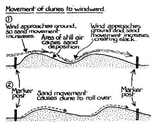
Most sand which blows on to a dune is deposited on the windward face (Trew, 1973), but on this side the wind speed and saltation effects are also greater. The result is that sand moves over the top and settles on the lee side. Deposition in the further lee zone is limited, as the sand load has already been dropped. As wind speeds again approach the ground, they carve down as far as the non-erodable damp sand (in the absence of vegetation), creating a slack. As shown below, the result is a steepening of the windward slope, and a flattening of the lee slope, so that the whole dunegradually ‘rolls over’, and advances in the direction of the dominant wind, sometimes by as much as 7m (22 1/2′) a year.
Sand dune dynamics
Dune system development
The youngest dune, nearest the beach, is usually the highest, and has the most coherent form, that of a ridge parallel to the shoreline. The older landward dunes are usually lower, and of more complex shapes. The reason for the first dune being the highest is that it collects most of the saltating sand grains, and as it becomes vegetated, saltation cannot be initiated. Thus supplies of sand to the inner dunes are greatly reduced.
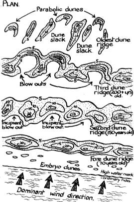
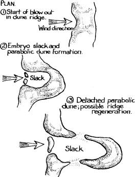
The parallel formation is broken when trampling or other agents initiate erosion in the ridge, creating a blowout. Large quantities of sand are blown over to the lee slope, making a bulge which moves downwind. The sides remain vegetated, creating a U shape, until the ‘arms’ eventually break away leaving an isolated ‘U shaped’ or ‘parabolic’ dune. The oldest dunes are dominated by the orientation of the arms, which is related to the dominant wind direction.
Where sand supplies are available, a new ridge may form at the mouth of the blowout.
Prograding or eroding systems
The classic formation of a dune system, as described above, will vary greatly according to factors of wind, sand supply, orientation and local topography, as well as the activities of man.
Where sand supply is limited because the beach is narrow, any dunes which form are likely to erode unless the feeder zone is long, and winds blow oblique to the shore. Dunes in small bays may become stable at a low level, then erode and recycle. An open coast with an abundant sand supply is most likely to take the form shown above.
Where sand is plentiful, so that foredunes continue to grow rather than becoming stabilised in place at an early stage, one of two things may happen. Where the high-level backshore is broad and onshore winds are moderate, new foredunes may form to seaward of the first ones in a ‘prograding’ or ‘fixed’ system. Or, where the backshore is narrow and prevailing and dominant winds are onshore, the foredunes may grow to a certain height and then start to erode and move landward, forming an ‘eroding’ or ‘plastic’ system.
In prograding systems the seaward growth of dunes is limited by the height of storm tides which undercut them and form near-vertical seaward faces. The eroded sand may form offshore bars to supply material for renewed dune formation, provided there is no offshore dredging. Behind this seaward ridge, the dunes in a progradingsystem are often quite stable.
Where prevailing winds are directly onshore, as is the case on many west-coast sites, the highest dunes are usually some way inland where wind speeds are slightly reduced. Where prevailing winds are offshore, as at Strathbeg. Aberdeen and on the east coast generally, the highest dunes are likely to be the coast dunes themselves which grade directly into dune pastures.
An understanding of wind effects shows why a system such as Ynyslas Dunes (Dyfi NNR), Dyfed, is particularly vulnerable to visitor pressure. This system projects out into the mouth of the Dyfi estuary and is subject to both prevailing westerlies and storm easterlies. It is so narrow that strong winds from either direction coupled with high tides tend to disperse the dunes rather than build them up, although there is adequate offshore sand for their renewal after erosion.
Local instability
Any area of dry sand, whether vegetated or not, forms a potential instability zone. In many dune systems, local erosion followed by regeneration of new foredunes proceeds naturally in what Ritchie (1972) emphasises is a state of dynamic equilibrium. Factors influencing erosion include: the direction and strength of the prevailing and storm winds: the incidence of gales; the reach of the tides and their coincidence with strong winds; the removal of sand leg by quarrying or by passive interference in natural beach drift from coastal protection devices); biotic factors such as grazing (especially by rabbits), fires, tree removal, wear and tear by people (which causes problems of wind funnel along paths and the death of sand-trapping and stabilising grasses); and structures which cause scour such as large concrete barriers or Second World War defences. As new embryo dunes build up, the sand supply to existing dunes is cut off and they become more subject to visitor damage. This has occurred for example at Gibraltar Point, Lincolnshire, bringing serious duneerosion problems to what had been a fairly stable system.
Erosion normallv occurs as blowouts in the dune ridge. Blowout formation is extremely varied and depends on local winds and topography and on associated flat erosional surfaces where the blowout reaches the water table, buried organic horizons, layers of shingle or anything else which stops it deepening. Associated with blowouts are redepositional hillocks. These are normally amorphous or conical, at least in Scotland under variable wind conditions, and their location is related to the direction of the excavating wind. Where dune ridges lie in roughly parallel series, blowout sand may be deposited on the next ridge downwind.
Where blowouts develop in coastal dunes or where storm tides erode a dune ridge, new embryo dunes are established mainly through the rerooting of rhizomefragments from toppled clumps of marram (Ammophila arenaria). This is a sort of natural equivalent to the transplantation techniques discussed in Chapter 7 – Vegetation Establishment. This natural regeneration is prevented at places such as Holkham, Norfolk, where the seaward dunes have been afforested and the marram shaded out, with serious consequences where the dunes act as a wall to protect low-lying land behind.
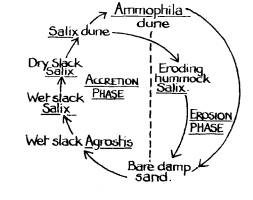
In large, deep dune systems such as Newborough Warren, natural erosion may be followed by renewed accretion in the blowout base. This cycling is inexact and the overall picture is very complex, since blowouts in different parts of the system may evolve at different rates, but it must be taken into account if management efforts are not to be wasted in a misguided attempt to fix the dunes. Changes are both geomorphological and vegetational. A typical cycle is shown schematically below (after Ranwell, 1960. p130).
Machairs, although they appear at first glance to be relatively unchanging, do undergo a slow but continuous cycle of growth and erosion. Grass grows up through accumulating layers of blown sand until the ground level becomes too high and dry for the turf to repair itself after some minor damage such as rabbit burrowing. This opens up an erosion face which eats back through the machair, stripping it down to a wet sand level which eventually revegetates. The whole cycle may take many centuries on most machairs but it can be much quicker in exposed cliff-top machairs such as at Sangomore, Sutherland. Machairs which suffer from visitor pressure are vulnerable mainly in the revegetation phase, when trampling of the ‘naturally’ eroded surface prevents the re-establishment of a closed turf (Countryside Commission for Scotland, 1977).